North Lombok is dominated by the massive Gunung Rinjani volcano, and most of the villages here sits on the slopes of the mountain or along the narrow coastline.

Many travelers come here on their way to the Gili islands or to climb Gunung Rinjani, and will therefore miss the rest of the beautiful landscape with waterfalls, the great view over the ocean and the mountain and the traditional villages.
The road from Pemenang north of Senggigi via Bangsal to Obel Obel and East Lombok follows the coast contour and the traffic can be slow sometimes. The road passes through several small villages mostly populated by Sasak people, of which many follows the unique Wektu Telu religion (see Lombok facts). Two kilometer north of Pemenang there is a road going out to Sira, one of the longest white sand beaches on Lombok
. There is still no tourist facilities here, but the beach and the view of the Gili islands is very nice.

Further north you will arrive at Tanjung,the most densely populated village in this area, with an interesting market. Around Tanjung you can see “mountains” of coconut shells; extraction of oil from coconuts is a big business here. Four km inland from Godang there is a 30 meter high waterfall called Air Terjun Tiu Pupas, the road to the waterfall is in very bad shape and the waterfall can be dry outside the wet season.
sildenafil and apomorphine). However, clinical trials areFurther Specialised Tests include : cialis.
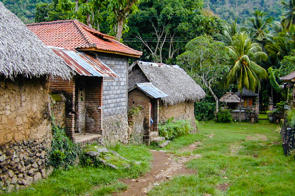
. Rinjani” src=”http://www.photoshelter.com/img-get/I000051c8kkPjZwI/s/960/640/Indonesia-Nusa-Tenggara-Lombok-0070-Lombok.jpg” alt=”Nusa Tenggara, Lombok. Rinjani. A traditional Sasak village on the slopes of Gunung Rinjani, this one is located south of Bayan. (Bjorn Grotting)” width=”960″ border=”0″ /> Nusa Tenggara, Lombok. Rinjani. A traditional Sasak village on the slopes of Gunung Rinjani, this one is located south of Bayan. (Photo Bjorn Grotting)
The traditional village of Segenter can be hard to find, but is worth a visit. It is located about 2 km south of the main road, a bad track turns off 1 km west of Sukadana at the northernmost point of the island. The Bayan village is probably the place of origin for the local Wektu Telu religion, but also home to orthodox Muslims. The mosque here is the oldest on Lombok, more than 300 years old, and ordinary Muslims are not happy about their holiest mosque being located in an area dominated by Wektu Telu followers.
A steep road goes from Bayan to Senaru, a popular starting point for trekking to the top of Gunung Rinjani, here you can also find some accommodation with a great view to the mountain and the valley below. Here is also some nice waterfalls, Air Terjun Singang, and a traditional village, Desa Adat Senaru.

Further east from Bayan you can continue towards Labuhan Lombok on the east coast, where the ferries to Sumbawa arrives and departs. On the way it is possible to take a boat to the uninhabited islands of Gili Sulat and Gili Pentangan, both with beautiful beaches and good snorkeling conditions, but no facilities.
Another alternative from Bayan is to take a detour through the Sembalun valley with the Sembalun Bumbung and Sembalun Lawang villages, from where it is possible to walk to Gunung Rinjani. The people in this valley claim that they are descendants of Hindu Javanese. Gajah Mada, the prime minister of Majapahit, supposedly came ashore on the north coast of Lombok in the 14th century.
From the south you can reach the Sapit village on the southern slopes of Rinjani, also a popular place for trekking to the top of the volcano. From Sapit there is a lovely view towards Sumbawa and Gunung Rinjani.